Geolocate

Sakti topographic map

Click on the map to display elevation.

About this map

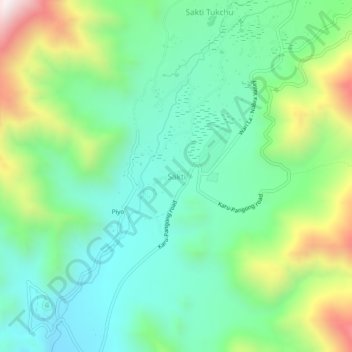
Name: Sakti topographic map, elevation, terrain.

Location: Sakti, Leh Tehsil, Leh district, Ladakh, India (33.95380 77.78688 33.99380 77.82688)

Average elevation: 3,842 m

Minimum elevation: 3,574 m

Maximum elevation: 4,461 m

Other topographic maps

Click on a map to view its topography, its elevation and its terrain.

Gear up for your next adventure:

🧤Thermal Hiking Gloves - Grip-enhanced gloves for cold-weather altitude trekking
🧦Crew Hiking Socks - Comfortable socks for long-distance hikes
🔋Lithium AA Batteries - Long-lasting power that performs in extreme cold
🥾Trekking Poles - Adjustable trekking poles to reduce knee stress and improve stability
🛶Waterproof Dry Bags - Keep electronics and clothes dry during river crossings

As an Amazon Associate, this site earns from qualifying purchases at no extra cost to you.