
Make a donation
Gear up for your next adventure:
As an Amazon Associate, this site earns from qualifying purchases at no extra cost to you.
Döringstadt topographic map
Click on the map to display elevation.
Make a donation
Gear up for your next adventure:
As an Amazon Associate, this site earns from qualifying purchases at no extra cost to you.
About this map
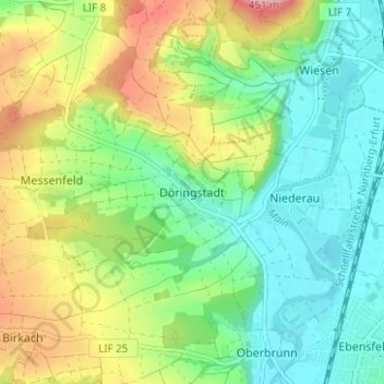
Name: Döringstadt topographic map, elevation, terrain.
Average elevation: 299 m
Minimum elevation: 244 m
Maximum elevation: 400 m
Make a donation
Gear up for your next adventure:
As an Amazon Associate, this site earns from qualifying purchases at no extra cost to you.
Other topographic maps
Click on a map to view its topography, its elevation and its terrain.
Lichtenfels
Deutschland > Bayern > Landkreis Lichtenfels
Bohnberg | Buch am Forst | Burgberg | Degendorf | Eichig | Friesenhof | Gnellenroth | Hammer | Heinach | Isling | Karolinenhöhe | Klosterlangheim | Kösten | Köttel | Krappenroth | Lahm | Mistelfeld | Mönchkröttendorf | Nassanger | Oberlangheim | Oberwallenstadt | Reundorf | Roth | Rothmannsthal | Schney |…
Average elevation: 348 m