
Thank you for supporting this site ❤️
Make a donation
Make a donation
Gear up for your next adventure:
As an Amazon Associate, this site earns from qualifying purchases at no extra cost to you.
Rinconada topographic map
Click on the map to display elevation.
Thank you for supporting this site ❤️
Make a donation
Make a donation
Gear up for your next adventure:
As an Amazon Associate, this site earns from qualifying purchases at no extra cost to you.
About this map
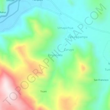
Name: Rinconada topographic map, elevation, terrain.
Location: Rinconada, San Antón, Azángaro, Puno, Perú (-14.61935 -70.30386 -14.57935 -70.26386)
Average elevation: 4,150 m
Minimum elevation: 3,955 m
Maximum elevation: 4,551 m
Thank you for supporting this site ❤️
Make a donation
Make a donation
Gear up for your next adventure:
As an Amazon Associate, this site earns from qualifying purchases at no extra cost to you.