Geolocate

Hampstead topographic map

Click on the map to display elevation.

About this map

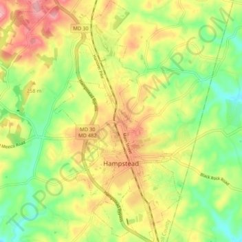
Name: Hampstead topographic map, elevation, terrain.

Location: Hampstead, Carroll County, Maryland, United States (39.58228 -76.87631 39.64543 -76.83283)

Average elevation: 242 m

Minimum elevation: 183 m

Maximum elevation: 307 m

Other topographic maps

Click on a map to view its topography, its elevation and its terrain.

New Port

United States > Maryland > Carroll County > Woodbine

Average elevation: 188 m

Spring Meadow

United States > Maryland > Carroll County

Average elevation: 219 m

Wesley Chapel

United States > Maryland > Carroll County

Average elevation: 205 m

Eldersburg

United States > Maryland > Carroll County

Average elevation: 166 m

Finksburg

United States > Maryland > Carroll County

Average elevation: 158 m

Shipley

United States > Maryland > Carroll County

Average elevation: 223 m

Finksburg

United States > Maryland > Carroll County

Average elevation: 158 m

Linden Estates

United States > Maryland > Carroll County

Average elevation: 206 m

Sunset Way

United States > Maryland > Carroll County

Average elevation: 237 m

Sunset Way

United States > Maryland > Carroll County

Average elevation: 237 m

Gist

United States > Maryland > Carroll County

Average elevation: 203 m

Woodbine

United States > Maryland > Carroll County

Average elevation: 182 m

Gear up for your next adventure:

🥫Freeze-Dried Meals - Lightweight, high-calorie nutrition for multi-day treks
💧Hydration Pack - Hands-free hydration system for long hikes
🥾Trekking Boots - Durable boots for long-distance trekking
🛶Kayak Dry Bag - Waterproof storage for kayaking adventures
🔨Vehicle Emergency Tool - Safety tool for remote road trips to trailheads

As an Amazon Associate, this site earns from qualifying purchases at no extra cost to you.