
Bengala Occidental topographic map
Interactive map
Click on the map to display elevation.
About this map
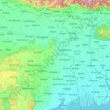
Name: Bengala Occidental topographic map, elevation, terrain.
Location: Bengala Occidental, India (21.54227 85.82009 27.22120 89.87254)
Average elevation: 182 m
Minimum elevation: -3 m
Maximum elevation: 4,084 m
Other topographic maps
Click on a map to view its topography, its elevation and its terrain.
Bardhaman
India > Bengala Occidental > Bardhaman
Bardhaman, Barddhamān, Purba Bardhaman, Bengala Occidental, 713101, India
Average elevation: 30 m