Make a donation
Gear up for your next adventure:
As an Amazon Associate, this site earns from qualifying purchases at no extra cost to you.
Mauriac topographic map
Click on the map to display elevation.
Make a donation
Gear up for your next adventure:
As an Amazon Associate, this site earns from qualifying purchases at no extra cost to you.
Mauriac
Mauriac is in hilly terrain, with the main populated area falling into a zone at an altitude of about 350–450 metres, while the surrounding areas rise to about 760 metres in the volcanic foothills.
Make a donation
Gear up for your next adventure:
As an Amazon Associate, this site earns from qualifying purchases at no extra cost to you.
About this map
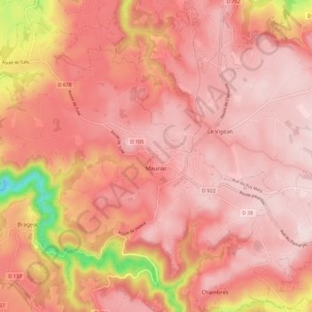
Name: Mauriac topographic map, elevation, terrain.
Average elevation: 671 m
Minimum elevation: 381 m
Maximum elevation: 767 m
Make a donation
Gear up for your next adventure:
As an Amazon Associate, this site earns from qualifying purchases at no extra cost to you.
Other topographic maps
Click on a map to view its topography, its elevation and its terrain.
Make a donation
Gear up for your next adventure:
As an Amazon Associate, this site earns from qualifying purchases at no extra cost to you.
Les Trois Pierres
France > Auvergne-Rhône-Alpes > Cantal > Albepierre-Bredons
Average elevation: 1,225 m
Make a donation
Gear up for your next adventure:
As an Amazon Associate, this site earns from qualifying purchases at no extra cost to you.
