Geolocate

Kevin topographic map

Click on the map to display elevation.

About this map

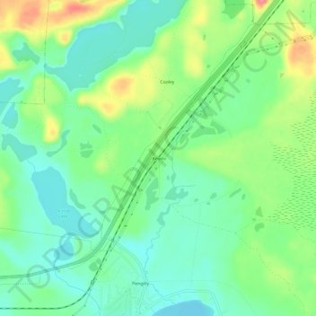
Name: Kevin topographic map, elevation, terrain.

Location: Kevin, Itasca County, Minnesota, 55775, United States (47.32855 -93.21381 47.36855 -93.17381)

Average elevation: 431 m

Minimum elevation: 403 m

Maximum elevation: 486 m

Other topographic maps

Click on a map to view its topography, its elevation and its terrain.

Twin Lake

United States > Minnesota > Itasca County

Average elevation: 431 m

Big Fork River

United States > Minnesota > Itasca County

Average elevation: 404 m

Burrows Lake

United States > Minnesota > Itasca County

Average elevation: 426 m

Gear up for your next adventure:

🦟Insect Repellent - Keep mosquitoes and black flies away in wooded areas
🔋Emergency Crank Radio - Weather alerts and power without needing batteries
🔭Outdoor Binoculars - Lightweight binoculars for birdwatching and hiking
🧥Softshell Jacket - Windproof and breathable jacket for hiking
🐕Hiking Dog Pack - Let your canine companion carry their own water and food

As an Amazon Associate, this site earns from qualifying purchases at no extra cost to you.