
Shenendoah City topographic map
Interactive map
Click on the map to display elevation.
About this map
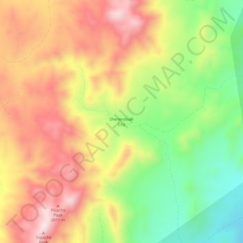
Name: Shenendoah City topographic map, elevation, terrain.
Location: Shenendoah City, Beaver County, Utah, United States (38.33219 -113.15718 38.37219 -113.11718)
Average elevation: 1,851 m
Minimum elevation: 1,592 m
Maximum elevation: 2,097 m
Other topographic maps
Click on a map to view its topography, its elevation and its terrain.
Minersville
United States > Utah > Beaver County
Minersville, Beaver County, Utah, 84752, United States
Average elevation: 1,685 m
Dead Horse Point
United States > Utah > Beaver County
Dead Horse Point, Beaver County, Utah, United States
Average elevation: 1,615 m
Milford
United States > Utah > Beaver County
Milford, Beaver County, Utah, 84751, United States
Average elevation: 1,525 m