
Make a donation
Gear up for your next adventure:
As an Amazon Associate, this site earns from qualifying purchases at no extra cost to you.
Oostwinkel topographic map
Click on the map to display elevation.
Make a donation
Gear up for your next adventure:
As an Amazon Associate, this site earns from qualifying purchases at no extra cost to you.
Oostwinkel
Oostwinkel ligt in Zandig Vlaanderen op een hoogte van ongeveer 12 meter. De hoogte varieert van 6 tot 19 meter. In het oosten bevond zich de Lieve, welke omstreeks 1855 opgenomen werd in het Schipdonkkanaal.
Make a donation
Gear up for your next adventure:
As an Amazon Associate, this site earns from qualifying purchases at no extra cost to you.
About this map
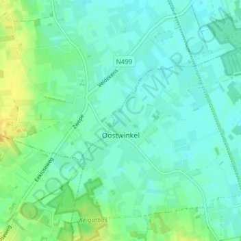
Name: Oostwinkel topographic map, elevation, terrain.
Location: Oostwinkel, Lievegem, Gent, Oost-Vlaanderen, 9931, België (51.13634 3.51215 51.17013 3.57559)
Average elevation: 10 m
Minimum elevation: 2 m
Maximum elevation: 28 m
Make a donation
Gear up for your next adventure:
As an Amazon Associate, this site earns from qualifying purchases at no extra cost to you.
Other topographic maps
Click on a map to view its topography, its elevation and its terrain.