
Make a donation
Gear up for your next adventure:
As an Amazon Associate, this site earns from qualifying purchases at no extra cost to you.
Suvarna topographic map
Click on the map to display elevation.
Make a donation
Gear up for your next adventure:
As an Amazon Associate, this site earns from qualifying purchases at no extra cost to you.
About this map
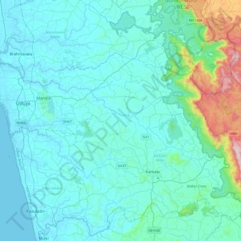
Name: Suvarna topographic map, elevation, terrain.
Location: Suvarna, Udupi taluku, Udupi District, Karnataka, India (13.16628 74.69238 13.45328 75.15268)
Average elevation: 133 m
Minimum elevation: -3 m
Maximum elevation: 1,195 m
Make a donation
Gear up for your next adventure:
As an Amazon Associate, this site earns from qualifying purchases at no extra cost to you.
Other topographic maps
Click on a map to view its topography, its elevation and its terrain.
Udupi
India > Karnataka > Udupi taluku
Udupi has an elevation of 27 m (89 ft) above mean sea level. The climate in Udupi is hot in summers and pleasant in winter. During summers (from March to May) the temperature reaches up to 38 °C (100 °F) and in winters (from December to February) it is usually between 32 and 20 °C (90 and 68 °F). As it is…
Average elevation: 17 m