
Make a donation
Gear up for your next adventure:
As an Amazon Associate, this site earns from qualifying purchases at no extra cost to you.
Western Sahara topographic map
Click on the map to display elevation.
Make a donation
Gear up for your next adventure:
As an Amazon Associate, this site earns from qualifying purchases at no extra cost to you.
About this map
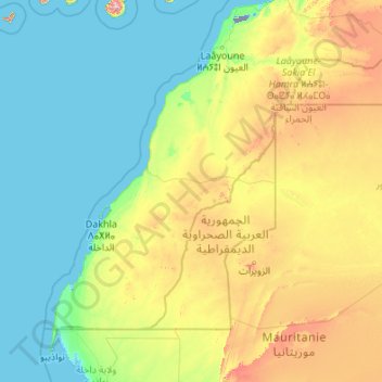
Name: Western Sahara topographic map, elevation, terrain.
Location: Western Sahara, Morocco (20.66725 -17.31902 27.67063 -8.66625)
Average elevation: 179 m
Minimum elevation: -60 m
Maximum elevation: 1,777 m
Make a donation
Gear up for your next adventure:
As an Amazon Associate, this site earns from qualifying purchases at no extra cost to you.
Other topographic maps
Click on a map to view its topography, its elevation and its terrain.
Ifegh
Morocco > Cercle de Goulmima دائرة كلميمة > Aghbalou N'Kerdous اغبالو انكردوس
Average elevation: 1,321 m
Make a donation
Gear up for your next adventure:
As an Amazon Associate, this site earns from qualifying purchases at no extra cost to you.