
Thank you for supporting this site ❤️
Make a donation
Make a donation
Gear up for your next adventure:
As an Amazon Associate, this site earns from qualifying purchases at no extra cost to you.
Paraduça topographic map
Click on the map to display elevation.
Thank you for supporting this site ❤️
Make a donation
Make a donation
Gear up for your next adventure:
As an Amazon Associate, this site earns from qualifying purchases at no extra cost to you.
About this map
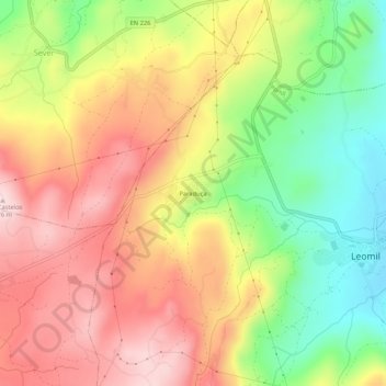
Name: Paraduça topographic map, elevation, terrain.
Location: Paraduça, Leomil, Moimenta da Beira, Viseu, 3620-165, Portugal (40.97010 -7.69835 41.01010 -7.65835)
Average elevation: 835 m
Minimum elevation: 684 m
Maximum elevation: 969 m
Thank you for supporting this site ❤️
Make a donation
Make a donation
Gear up for your next adventure:
As an Amazon Associate, this site earns from qualifying purchases at no extra cost to you.