
Make a donation
Gear up for your next adventure:
As an Amazon Associate, this site earns from qualifying purchases at no extra cost to you.
Abucay topographic map
Click on the map to display elevation.
Make a donation
Gear up for your next adventure:
As an Amazon Associate, this site earns from qualifying purchases at no extra cost to you.
Abucay
Topography of Abucay varies from the mountainous terrain of Mount Natib caldera in the west to the coastal areas of the province along the shore of Manila Bay. Six rivers with a combined length of 37 kilometres (23 mi) originate from the mountain flowing in the west-to-east direction.
Make a donation
Gear up for your next adventure:
As an Amazon Associate, this site earns from qualifying purchases at no extra cost to you.
About this map
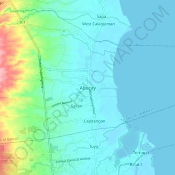
Name: Abucay topographic map, elevation, terrain.
Location: Abucay, Bataan, Central Luzon, 2114, Philippines (14.68131 120.49487 14.76131 120.57487)
Average elevation: 22 m
Minimum elevation: 0 m
Maximum elevation: 129 m
Make a donation
Gear up for your next adventure:
As an Amazon Associate, this site earns from qualifying purchases at no extra cost to you.