
Make a donation
Gear up for your next adventure:
As an Amazon Associate, this site earns from qualifying purchases at no extra cost to you.
East Wenatchee topographic map
Click on the map to display elevation.
Make a donation
Gear up for your next adventure:
As an Amazon Associate, this site earns from qualifying purchases at no extra cost to you.
About this map
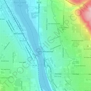
Name: East Wenatchee topographic map, elevation, terrain.
Location: East Wenatchee, Douglas County, Washington, United States (47.39791 -120.30946 47.43725 -120.26026)
Average elevation: 248 m
Minimum elevation: 184 m
Maximum elevation: 460 m
Make a donation
Gear up for your next adventure:
As an Amazon Associate, this site earns from qualifying purchases at no extra cost to you.
Other topographic maps
Click on a map to view its topography, its elevation and its terrain.
Make a donation
Gear up for your next adventure:
As an Amazon Associate, this site earns from qualifying purchases at no extra cost to you.
Moses Coulee
United States > Washington > Douglas County
Pleistocene glaciers advanced onto the Waterville Plateau, with the Okanogan Lobe of the Cordilleran Ice Sheet reaching as far south as the town of Withrow. Evidence for glaciation on the Waterville Plateau includes polished and striated bedrock, glacial erratics, drumlinoid topography, eskers, moraines,…
Average elevation: 666 m