
Make a donation
Gear up for your next adventure:
As an Amazon Associate, this site earns from qualifying purchases at no extra cost to you.
Allmendingen topographic map
Click on the map to display elevation.
Make a donation
Gear up for your next adventure:
As an Amazon Associate, this site earns from qualifying purchases at no extra cost to you.
Allmendingen
Die Gemeinde Allmendingen führt seit dem Jahr 2000 eine Sanierung ihres Ortskerns durch. Neben öffentlichen werden auch private Maßnahmen gefördert. Innerhalb des Sanierungsabschnitts I wurde das Alte Schulhaus, erbaut 1885, zu einem Bürgerhaus umgebaut. Das Land Baden-Württemberg stellte für den ersten Sanierungsabschnitt insgesamt Zuwendungen in Höhe von 1,68 Millionen Euro zur Verfügung. Das entspricht einer Förderung von 60 % aus zuschussfähigen Gesamtkosten von 2,8 Millionen Euro. Mit diesen Mitteln wurden öffentliche und private Maßnahmen städtebauliche Mängel und Missstände behoben und die Lebens-, Arbeits- und Wohnbedingungen in der Ortsmitte verbessert.
Make a donation
Gear up for your next adventure:
As an Amazon Associate, this site earns from qualifying purchases at no extra cost to you.
About this map
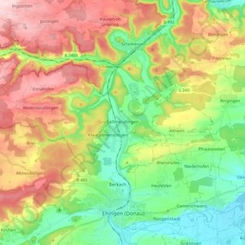
Name: Allmendingen topographic map, elevation, terrain.
Average elevation: 609 m
Minimum elevation: 485 m
Maximum elevation: 786 m
Make a donation
Gear up for your next adventure:
As an Amazon Associate, this site earns from qualifying purchases at no extra cost to you.
Other topographic maps
Click on a map to view its topography, its elevation and its terrain.
Balzheim
Deutschland > Baden-Württemberg > Alb-Donau-Kreis > Balzheim > Balzheim
Average elevation: 548 m
Rißtissen
Deutschland > Baden-Württemberg > Alb-Donau-Kreis > Ehingen (Donau)
Average elevation: 494 m