
Mount Benson topographic map
Interactive map
Click on the map to display elevation.
About this map
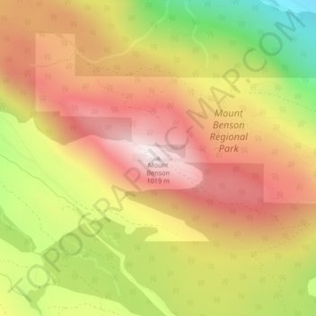
Name: Mount Benson topographic map, elevation, terrain.
Average elevation: 693 m
Minimum elevation: 272 m
Maximum elevation: 1,007 m
Regional District of Nanaimo trails, hiking, mountain biking, running and outdoor activities
Other topographic maps
Click on a map to view its topography, its elevation and its terrain.
Jewel Lake
Canada > British Columbia > Regional District of Nanaimo > Area C (Arrowsmith-Benson)
Average elevation: 1,338 m
Fishtail Lake
Canada > British Columbia > Regional District of Nanaimo > Area C (Arrowsmith-Benson)
Average elevation: 1,155 m