
Make a donation
Gear up for your next adventure:
As an Amazon Associate, this site earns from qualifying purchases at no extra cost to you.
Müllheim topographic map
Click on the map to display elevation.
Make a donation
Gear up for your next adventure:
As an Amazon Associate, this site earns from qualifying purchases at no extra cost to you.
Müllheim
Das Stadtgebiet dehnt sich in Ost-West-Richtung auf 15 Kilometer aus, von Norden nach Süden sind es zehn Kilometer. Der am niedrigsten gelegene Teil der Gemarkung befindet sich bei 230 m Höhe über NN an der westlichen Gemarkungsgrenze in Richtung der Nachbarstadt Neuenburg am Rhein in der Rheinebene, der höchste Teil liegt mit 1224 m über NN an der Sirnitz an der östlichen Gemarkungsgrenze im südlichen Schwarzwald. Die Fläche der Gemeinde beträgt 57,90 km², davon sind 16 km² Wald und ca. 5 km² Reben, der Rest setzt sich aus Wiesenflächen, Obst-Anlagen, Feldern und Äckern, Industrie- und Gewerbegebieten sowie Wohnflächen zusammen.
Make a donation
Gear up for your next adventure:
As an Amazon Associate, this site earns from qualifying purchases at no extra cost to you.
About this map
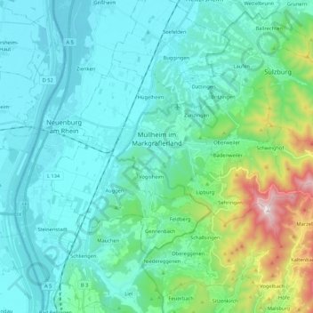
Name: Müllheim topographic map, elevation, terrain.
Average elevation: 362 m
Minimum elevation: 198 m
Maximum elevation: 1,160 m
Make a donation
Gear up for your next adventure:
As an Amazon Associate, this site earns from qualifying purchases at no extra cost to you.
Other topographic maps
Click on a map to view its topography, its elevation and its terrain.
Rheintal
Deutschland > Baden-Württemberg > Landkreis Breisgau-Hochschwarzwald > Müllheim im Markgräflerland
Average elevation: 424 m
Titisee
Deutschland > Baden-Württemberg > Landkreis Breisgau-Hochschwarzwald > Titisee
Average elevation: 917 m
Sägendobel
Deutschland > Baden-Württemberg > Landkreis Breisgau-Hochschwarzwald > St. Peter
Average elevation: 859 m
Bachheim
Deutschland > Baden-Württemberg > Landkreis Breisgau-Hochschwarzwald > Löffingen > Bachheim
Average elevation: 729 m
Make a donation
Gear up for your next adventure:
As an Amazon Associate, this site earns from qualifying purchases at no extra cost to you.
Oberbränd
Deutschland > Baden-Württemberg > Landkreis Breisgau-Hochschwarzwald > Eisenbach
Average elevation: 970 m