
Make a donation
Gear up for your next adventure:
As an Amazon Associate, this site earns from qualifying purchases at no extra cost to you.
Kunigal topographic map
Click on the map to display elevation.
Make a donation
Gear up for your next adventure:
As an Amazon Associate, this site earns from qualifying purchases at no extra cost to you.
Kunigal
Kunigal is located at 13°01′N 77°02′E / 13.02°N 77.03°E / 13.02; 77.03. It has an average elevation of 773 metres (2536 feet). It is situated on the National Highway 75 (India) connecting Bengaluru and Mangaluru and State Highway 33 (Karnataka) connecting Tumakuru and Madduru. Kunigal is situated 70 kilometres west of Bengaluru and 115 kilometres north of Mysuru. Recently opened Hassan-Bangalore railway line transverses through Kunigal.
Make a donation
Gear up for your next adventure:
As an Amazon Associate, this site earns from qualifying purchases at no extra cost to you.
About this map
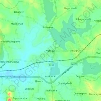
Name: Kunigal topographic map, elevation, terrain.
Location: Kunigal, Kunigal taluk, Tumakuru, Karnataka, 572130, India (12.98602 76.98227 13.06602 77.06227)
Average elevation: 775 m
Minimum elevation: 751 m
Maximum elevation: 850 m
Make a donation
Gear up for your next adventure:
As an Amazon Associate, this site earns from qualifying purchases at no extra cost to you.