
Serre Menu topographic map
Click on the map to display elevation.
About this map
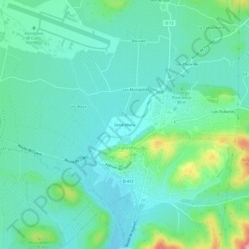
Name: Serre Menu topographic map, elevation, terrain.
Average elevation: 79 m
Minimum elevation: 42 m
Maximum elevation: 209 m
Other topographic maps
Click on a map to view its topography, its elevation and its terrain.
Le Réal Martin
France > Provence-Alpes-Côte d'Azur > Var > Pierrefeu-du-Var
La longueur de son cours d'eau est de 28 km. Le Réal Martin prend sa source, à l'altitude 215 mètres, sur la commune de Pignans, près du lieu-dit les Plaines, au nord de la Forêt domaniale des Maures et des sommets Le Cros de Panau (684 m) et Notre-Dame des Anges (768 m).
Average elevation: 176 m