
Thank you for supporting this site ❤️
Make a donation
Make a donation
Gear up for your next adventure:
As an Amazon Associate, this site earns from qualifying purchases at no extra cost to you.
Colfiorito topographic map
Click on the map to display elevation.
Thank you for supporting this site ❤️
Make a donation
Make a donation
Gear up for your next adventure:
As an Amazon Associate, this site earns from qualifying purchases at no extra cost to you.
About this map
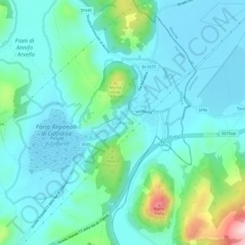
Name: Colfiorito topographic map, elevation, terrain.
Location: Colfiorito, Foligno, Perugia, Umbria, 06034, Italy (43.00695 12.87027 43.04695 12.91027)
Average elevation: 803 m
Minimum elevation: 745 m
Maximum elevation: 1,054 m
Thank you for supporting this site ❤️
Make a donation
Make a donation
Gear up for your next adventure:
As an Amazon Associate, this site earns from qualifying purchases at no extra cost to you.