Geolocate

El Turro topographic map

Click on the map to display elevation.

About this map
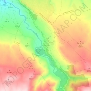
Name: El Turro topographic map, elevation, terrain.

Location: El Turro, Cacín, Comarca de Alhama, Granada, Andalucía, 18129, España (37.11339 -3.96227 37.15339 -3.92227)

Average elevation: 723 m

Minimum elevation: 566 m

Maximum elevation: 848 m

Other topographic maps

Click on a map to view its topography, its elevation and its terrain.

Arenas del Rey

España > Andalucía > Comarca de Alhama

Average elevation: 1,084 m

Escúzar

España > Andalucía > Comarca de Alhama

Average elevation: 932 m

Cacín

España > Andalucía > Comarca de Alhama

Average elevation: 836 m

Zafarraya

España > Andalucía > Comarca de Alhama

Average elevation: 1,085 m

La Malahá

España > Andalucía > Comarca de Alhama

Average elevation: 779 m

Chimeneas

España > Andalucía > Comarca de Alhama

Average elevation: 767 m

Gear up for your next adventure:

🥾Hiking Shoes - Durable and comfortable shoes for trail hiking
🧤Insulated Winter Gloves - Heavy-duty protection for sub-zero Canadian adventures
🔭Compact Binoculars - Lightweight optics for scouting trails and wildlife
🦟Insect Repellent - Keep mosquitoes and black flies away in wooded areas
🥘Camping Cookware Set - Compact nesting pots and pans for trail cooking

As an Amazon Associate, this site earns from qualifying purchases at no extra cost to you.