Geolocate

Nash topographic map

Click on the map to display elevation.

About this map

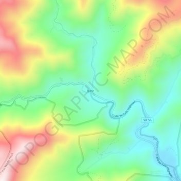
Name: Nash topographic map, elevation, terrain.

Location: Nash, Nelson County, Virginia, 22976, United States (37.83764 -79.06614 37.87764 -79.02614)

Average elevation: 544 m

Minimum elevation: 286 m

Maximum elevation: 959 m

Gear up for your next adventure:

💡Solar Camping Lamp - Eco-friendly lighting for campsites
🦶Hiking Shoe Insoles - Added support for high arches and long days on feet
🚲MTB Frame Bag - Carry tools and maps directly on your bicycle frame
🥽Outdoor Goggles - Protective eyewear for outdoor activities
🔦LED Flashlight - Powerful and long-lasting flashlight for camping and emergencies

As an Amazon Associate, this site earns from qualifying purchases at no extra cost to you.