
Thank you for supporting this site ❤️
Make a donation
Make a donation
Gear up for your next adventure:
As an Amazon Associate, this site earns from qualifying purchases at no extra cost to you.
Feitús topographic map
Click on the map to display elevation.
Thank you for supporting this site ❤️
Make a donation
Make a donation
Gear up for your next adventure:
As an Amazon Associate, this site earns from qualifying purchases at no extra cost to you.
About this map
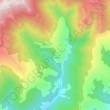
Name: Feitús topographic map, elevation, terrain.
Location: Feitús, Llanars, Ripollés, Gerona, Cataluña, 17869, España (42.33156 2.33355 42.37156 2.37355)
Average elevation: 1,413 m
Minimum elevation: 1,017 m
Maximum elevation: 1,893 m
Thank you for supporting this site ❤️
Make a donation
Make a donation
Gear up for your next adventure:
As an Amazon Associate, this site earns from qualifying purchases at no extra cost to you.