
Make a donation
Gear up for your next adventure:
As an Amazon Associate, this site earns from qualifying purchases at no extra cost to you.
La Millaudrie topographic map
Click on the map to display elevation.
Make a donation
Gear up for your next adventure:
As an Amazon Associate, this site earns from qualifying purchases at no extra cost to you.
About this map
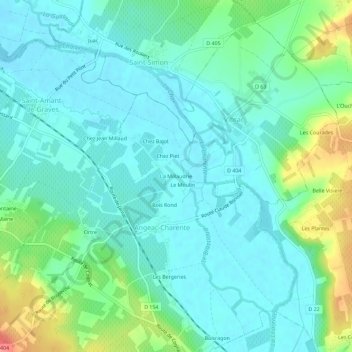
Name: La Millaudrie topographic map, elevation, terrain.
Average elevation: 32 m
Minimum elevation: 13 m
Maximum elevation: 92 m
Make a donation
Gear up for your next adventure:
As an Amazon Associate, this site earns from qualifying purchases at no extra cost to you.
Other topographic maps
Click on a map to view its topography, its elevation and its terrain.
Angeac-Charente
France > Nouvelle-Aquitaine > Charente > Angeac-Charente
Le sud de la commune consiste en un plateau boisé qui correspond au sommet de la cuesta et dont les pentes sont recouvertes de vignobles de cognac. Le point culminant est à une altitude de 100 m, situé sur ce plateau (borne IGN). Le point le plus bas est à 15 m, situé le long de la Charente en face de…
Average elevation: 40 m