Geolocate

Morges topographic map

Click on the map to display elevation.

About this map

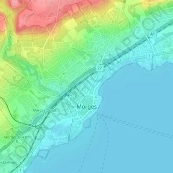
Name: Morges topographic map, elevation, terrain.

Location: Morges, District de Morges, Vaud, 1110, Switzerland (46.45625 6.47651 46.52375 6.52955)

Average elevation: 386 m

Minimum elevation: 369 m

Maximum elevation: 519 m

Other topographic maps

Click on a map to view its topography, its elevation and its terrain.

Morges

Switzerland > Vaud > District de Morges > Morges > Morges

Average elevation: 418 m

Mont Tendre

Switzerland > Vaud > District de Morges > Montricher

Average elevation: 1,508 m

Gear up for your next adventure:

🧢Sun Hat - Wide-brim hat for sun protection
Camping Groundsheet - Protect your tent from moisture and dirt
Camping Tent - Weather-resistant tents suitable for 2 to 6 people
🥾Hiking Boots - Sturdy boots providing ankle support and traction on rugged trails
🥾Light Trekking Boots - Supportive boots for multi-day treks

As an Amazon Associate, this site earns from qualifying purchases at no extra cost to you.