
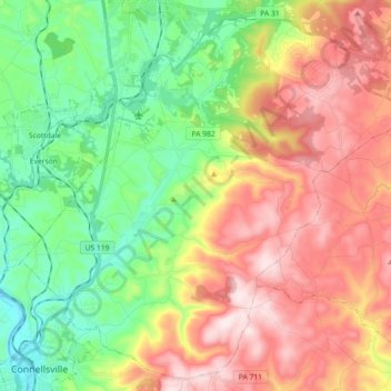
Bullskin Township topographic map
Interactive map
Click on the map to display elevation.
About this map
Name: Bullskin Township topographic map, elevation, terrain.
Average elevation: 458 m
Minimum elevation: 258 m
Maximum elevation: 713 m
Bullskin Township is in northeastern Fayette County, bordered to the north by Westmoreland County. The eastern border of the township follows the crest of Chestnut Ridge, reaching elevations of 2,340 feet (710 m) above sea level. According to the United States Census Bureau, the township has a total area of 43.64 square miles (113.02 km2), of which 43.53 square miles (112.75 km2) is land and 0.11 square miles (0.272 km2), or 0.24%, is water.
Other topographic maps
Click on a map to view its topography, its elevation and its terrain.
Bear Rocks
United States > Pennsylvania > Fayette County > Bullskin Township
Bear Rocks, Bullskin Township, Fayette County, Pennsylvania, 15610, United States
Average elevation: 571 m