
Make a donation
Gear up for your next adventure:
As an Amazon Associate, this site earns from qualifying purchases at no extra cost to you.
Schneeren topographic map
Click on the map to display elevation.
Make a donation
Gear up for your next adventure:
As an Amazon Associate, this site earns from qualifying purchases at no extra cost to you.
About this map
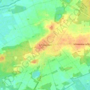
Name: Schneeren topographic map, elevation, terrain.
Average elevation: 53 m
Minimum elevation: 37 m
Maximum elevation: 73 m
Make a donation
Gear up for your next adventure:
As an Amazon Associate, this site earns from qualifying purchases at no extra cost to you.
Other topographic maps
Click on a map to view its topography, its elevation and its terrain.
31535
Deutschland > Niedersachsen > Region Hannover > Neustadt am Rübenberge > Mariensee
Average elevation: 43 m
31535
Deutschland > Niedersachsen > Region Hannover > Neustadt am Rübenberge > Mariensee
Average elevation: 43 m
Steinhuder Moor
Deutschland > Niedersachsen > Region Hannover > Neustadt am Rübenberge
Average elevation: 39 m