Geolocate

Morgan Island topographic map

Click on the map to display elevation.

About this map

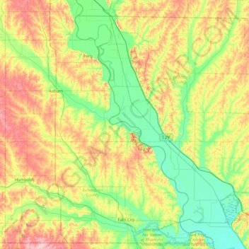
Name: Morgan Island topographic map, elevation, terrain.

Location: Morgan Island, Nemaha County, Nebraska, United States (39.98472 -95.92776 40.62472 -95.28776)

Average elevation: 309 m

Minimum elevation: 255 m

Maximum elevation: 408 m

Gear up for your next adventure:

🕯️Camping Lantern - Illuminates your entire campsite with high-efficiency LEDs
🧭Orienteering Kit - Tools for map reading and navigation in the wild
🚲Handlebar Phone Mount - View topographic-map.com live while cycling
🛏️Camping Sleeping Mat - Comfortable mats for sleeping outdoors
Family Camping Tent - Spacious tent suitable for family camping trips

As an Amazon Associate, this site earns from qualifying purchases at no extra cost to you.