
Make a donation
Gear up for your next adventure:
As an Amazon Associate, this site earns from qualifying purchases at no extra cost to you.
Ann Arbor topographic map
Click on the map to display elevation.
Make a donation
Gear up for your next adventure:
As an Amazon Associate, this site earns from qualifying purchases at no extra cost to you.
Ann Arbor
The landscape of Ann Arbor consists of hills and valleys, with the terrain becoming steeper near the Huron River. The elevation ranges from about 750 feet (230 m) along the Huron River to 1,015 feet (309 m) on the city's west side, near the intersection of Maple Road and Pauline Blvd. Ann Arbor Municipal Airport, which is south of the city at 42°13.38′N 83°44.74′W / 42.22300°N 83.74567°W / 42.22300; -83.74567, has an elevation of 839 feet (256 m).
Make a donation
Gear up for your next adventure:
As an Amazon Associate, this site earns from qualifying purchases at no extra cost to you.
About this map
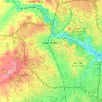
Name: Ann Arbor topographic map, elevation, terrain.
Location: Ann Arbor, Washtenaw County, Michigan, United States (42.22267 -83.79957 42.32389 -83.67581)
Average elevation: 272 m
Minimum elevation: 225 m
Maximum elevation: 328 m
Make a donation
Gear up for your next adventure:
As an Amazon Associate, this site earns from qualifying purchases at no extra cost to you.