Geolocate

Juakali topographic map

Click on the map to display elevation.

About this map

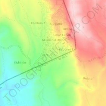
Name: Juakali topographic map, elevation, terrain.

Location: Juakali, Bahati, Nakuru, Kenya (-0.27702 36.21680 -0.23702 36.25680)

Average elevation: 2,363 m

Minimum elevation: 2,185 m

Maximum elevation: 2,547 m

Other topographic maps

Click on a map to view its topography, its elevation and its terrain.

Kabatini ward

Kenya > Nakuru > Bahati

Average elevation: 2,056 m

Kiamaina ward

Kenya > Nakuru > Bahati

Average elevation: 1,981 m

Bahati ward

Kenya > Nakuru > Bahati

Average elevation: 1,988 m

Gear up for your next adventure:

🧥Softshell Hiking Jacket - The perfect balance of wind protection and breathability
🧢Beanie Hat - Keep your head warm in cold weather
🥾Light Hiking Boots - Lightweight and comfortable boots for day hikes
🧴Waterproofing Spray - Restore the DWR coating on jackets and tents
🔭Outdoor Binoculars - Lightweight binoculars for birdwatching and hiking

As an Amazon Associate, this site earns from qualifying purchases at no extra cost to you.