
Make a donation
Gear up for your next adventure:
As an Amazon Associate, this site earns from qualifying purchases at no extra cost to you.
Grabenstetten topographic map
Click on the map to display elevation.
Make a donation
Gear up for your next adventure:
As an Amazon Associate, this site earns from qualifying purchases at no extra cost to you.
About this map
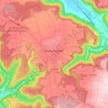
Name: Grabenstetten topographic map, elevation, terrain.
Average elevation: 661 m
Minimum elevation: 455 m
Maximum elevation: 776 m
Make a donation
Gear up for your next adventure:
As an Amazon Associate, this site earns from qualifying purchases at no extra cost to you.
Other topographic maps
Click on a map to view its topography, its elevation and its terrain.
Gönningen
Deutschland > Baden-Württemberg > Landkreis Reutlingen > Reutlingen
Average elevation: 608 m
Oberwilzingen
Deutschland > Baden-Württemberg > Landkreis Reutlingen > Hayingen
Average elevation: 637 m
Bronnweiler
Deutschland > Baden-Württemberg > Landkreis Reutlingen > Reutlingen
Average elevation: 520 m
Make a donation
Gear up for your next adventure:
As an Amazon Associate, this site earns from qualifying purchases at no extra cost to you.
Böhringen
Deutschland > Baden-Württemberg > Landkreis Reutlingen > Römerstein
Average elevation: 775 m