Geolocate

Barries Bay topographic map

Click on the map to display elevation.

About this map

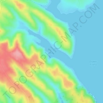
Name: Barries Bay topographic map, elevation, terrain.

Location: Barries Bay, Marin County, CAL Fire Northern Region, California, United States (38.05043 -122.95616 38.05053 -122.95606)

Average elevation: 33 m

Minimum elevation: -1 m

Maximum elevation: 110 m

Other topographic maps

Click on a map to view its topography, its elevation and its terrain.

Soulajule Dam

United States > California > Marin County

Average elevation: 167 m

Larkspur

United States > California > Marin County

Larkspur is a city in Marin County, California, United States. Larkspur is located 3 miles (4.8 km) south of San Rafael, at an elevation of 43 feet (13 m). As of the 2020 Census, the city's population was 13,064. Larkspur's Police Department is shared with that of the neighboring Corte Madera and town of San…

Average elevation: 53 m

Gear up for your next adventure:

🐕Hiking Dog Pack - Let your canine companion carry their own water and food
🥾Durable Hiking Shoes - Long-lasting shoes for frequent hiking
🧼Travel Hand Sanitizer - Keep hands clean when water is scarce
🚲Handlebar Phone Mount - View topographic-map.com live while cycling
🥾Waterproof Hiking Boots - Boots keeping your feet dry in wet conditions

As an Amazon Associate, this site earns from qualifying purchases at no extra cost to you.