Geolocate

Kavali topographic map

Click on the map to display elevation.

Kavali

Kavali is located at 14°54′47″N 79°59′35″E / 14.913001°N 79.992921°E / 14.913001; 79.992921. It has an average elevation of 17 metres (56 ft). The town is at a distance of 8 km from the Bay of Bengal.

Wikipedia (CC-BY-SA 3.0)

About this map

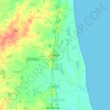
Name: Kavali topographic map, elevation, terrain.

Location: Kavali, Sri Potti Sriramulu Nellore District, Andhra Pradesh, 524200, India (14.75358 79.83269 15.07358 80.15269)

Average elevation: 15 m

Minimum elevation: 0 m

Maximum elevation: 72 m

Gear up for your next adventure:

👟Sport Hiking Sandals - Breathable footwear for water crossings and camp rest
🔥Camping Stove - Portable stoves to cook outdoors with ease
🧭GPS Tracker - Track your location in remote areas safely
Backpacking Tent - Lightweight tent for long-distance hiking trips
🧦Merino Wool Socks - Moisture-wicking comfort for long-distance hiking

As an Amazon Associate, this site earns from qualifying purchases at no extra cost to you.