Geolocate

Björklinge topographic map

Click on the map to display elevation.

About this map

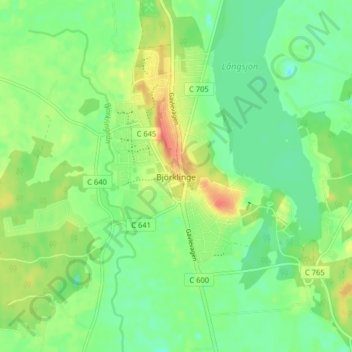
Name: Björklinge topographic map, elevation, terrain.

Location: Björklinge, Uppsala kommun, Uppsala County, 743 64, Sweden (60.00914 17.53143 60.04914 17.57143)

Average elevation: 35 m

Minimum elevation: 17 m

Maximum elevation: 61 m

Other topographic maps

Click on a map to view its topography, its elevation and its terrain.

Heby kommun

Sweden > Uppsala County

Average elevation: 61 m

Gear up for your next adventure:

🥾Mountain Trail Shoes - High-traction shoes for mountain trails
🧢Sun Hat - Wide-brim hat for sun protection
🧶550 Survival Paracord - Versatile utility cord for emergency repairs and rigging
🔦LED Headtorch - Bright and durable light for night activities
🥾All-Terrain Hiking Boots - Versatile boots for varied hiking conditions

As an Amazon Associate, this site earns from qualifying purchases at no extra cost to you.