Geolocate

Doganaccia topographic map

Click on the map to display elevation.

About this map

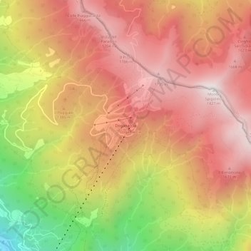
Name: Doganaccia topographic map, elevation, terrain.

Location: Doganaccia, Abetone Cutigliano, Pistoia, Tuscany, 51020, Italy (44.10198 10.75580 44.14198 10.79580)

Average elevation: 1,343 m

Minimum elevation: 588 m

Maximum elevation: 1,815 m

Other topographic maps

Click on a map to view its topography, its elevation and its terrain.

Montale

Italy > Tuscany > Pistoia

Average elevation: 318 m

Gear up for your next adventure:

🧥Ultralight Puffy Jacket - Maximum warmth that packs down to the size of an orange
🥾Hiking Leggings - Comfortable leggings for outdoor activities
🧥Softshell Hiking Jacket - The perfect balance of wind protection and breathability
🦌Outdoor Trail Camera - Monitor wildlife activity near your favorite spots
👟Sport Hiking Sandals - Breathable footwear for water crossings and camp rest

As an Amazon Associate, this site earns from qualifying purchases at no extra cost to you.