
Thank you for supporting this site ❤️
Make a donation
Make a donation
Gear up for your next adventure:
As an Amazon Associate, this site earns from qualifying purchases at no extra cost to you.
Alájar topographic map
Click on the map to display elevation.
Thank you for supporting this site ❤️
Make a donation
Make a donation
Gear up for your next adventure:
As an Amazon Associate, this site earns from qualifying purchases at no extra cost to you.
About this map
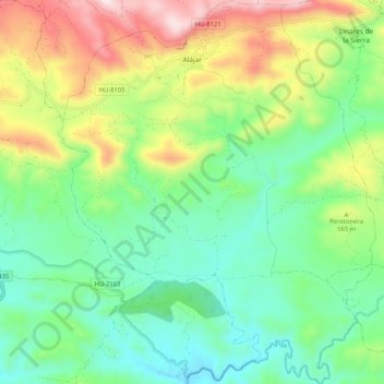
Name: Alájar topographic map, elevation, terrain.
Location: Alájar, Sierra de Huelva, Huelva, Andalusië, 21340, Spanje (37.80570 -6.70095 37.88692 -6.61587)
Average elevation: 485 m
Minimum elevation: 272 m
Maximum elevation: 904 m
Thank you for supporting this site ❤️
Make a donation
Make a donation
Gear up for your next adventure:
As an Amazon Associate, this site earns from qualifying purchases at no extra cost to you.
Other topographic maps
Click on a map to view its topography, its elevation and its terrain.
Sierra de La Corbera
Spanje > Andalusië > Sierra de Huelva > Santa Olalla del Cala
Average elevation: 428 m