Geolocate

Argentona topographic map

Click on the map to display elevation.

About this map
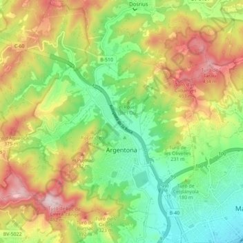
Name: Argentona topographic map, elevation, terrain.

Location: Argentona, Maresme, Barcelona, Catalonia, 08310, Spain (41.53048 2.35541 41.59531 2.42698)

Average elevation: 196 m

Minimum elevation: 3 m

Maximum elevation: 463 m

Other topographic maps

Click on a map to view its topography, its elevation and its terrain.
Palafolls

Spain > Catalonia > Maresme > Palafolls > Palafolls

Average elevation: 26 m

Gear up for your next adventure:

🚲Bike Repair Kit - Essential tools for on-trail mechanical issues
🕶️Polarized Sunglasses - Protect your eyes with durable polarized lenses
🥾Waterproof Hiking Boots - Boots keeping your feet dry in wet conditions
🧦Outdoor Socks - Durable socks designed for hiking and outdoor sports
💧Hydration Pack - Hands-free hydration system for long hikes

As an Amazon Associate, this site earns from qualifying purchases at no extra cost to you.