Geolocate

Redín topographic map

Click on the map to display elevation.

About this map

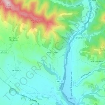
Name: Redín topographic map, elevation, terrain.

Location: Redín, Lizoain-Arriasgoiti, Prepirineo, Navarra, España (42.79373 -1.49077 42.83373 -1.45077)

Average elevation: 594 m

Minimum elevation: 493 m

Maximum elevation: 870 m

Gear up for your next adventure:

🧴Insect Repellent - Protect yourself from bugs during outdoor adventures
🚲Bike Repair Kit - Essential tools for on-trail mechanical issues
🔦UV Flashlight - Detect minerals or specific insects in the dark
💡Compact LED Flashlight - Powerful and portable flashlight for outdoor use
💧Filtered Water Bottle - Safe drinking water on the go

As an Amazon Associate, this site earns from qualifying purchases at no extra cost to you.