
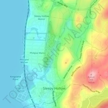
Village of Sleepy Hollow topographic map
Interactive map
Click on the map to display elevation.
About this map
Name: Village of Sleepy Hollow topographic map, elevation, terrain.
Average elevation: 46 m
Minimum elevation: 0 m
Maximum elevation: 147 m
Other topographic maps
Click on a map to view its topography, its elevation and its terrain.
City of New Rochelle
United States > New York > Westchester County
City of New Rochelle, Westchester County, New York, United States
Average elevation: 31 m
Furnace Woods
United States > New York > Westchester County > Town of Cortlandt
Furnace Woods, Town of Cortlandt, Westchester County, New York, 10567, United States
Average elevation: 116 m
Salem Center
United States > New York > Westchester County > Town of North Salem
Salem Center, Town of North Salem, Westchester County, New York, 10560, United States
Average elevation: 147 m
Town of North Salem
United States > New York > Westchester County
Town of North Salem, Westchester County, New York, United States
Average elevation: 179 m
Isle of San Souci
United States > New York > Westchester County > City of New Rochelle
Isle of San Souci, City of New Rochelle, Westchester County, New York, 10805, United States
Average elevation: 7 m
City of Yonkers
United States > New York > Westchester County
City of Yonkers, Westchester County, New York, United States
Average elevation: 58 m
Getty Square
United States > New York > Westchester County > City of Yonkers > Ludlow
Getty Square, Ludlow, City of Yonkers, Westchester County, New York, United States
Average elevation: 31 m
Van Cortlandtville
United States > New York > Westchester County > Town of Cortlandt
Van Cortlandtville, Town of Cortlandt, Westchester County, New York, 10567, United States
Average elevation: 80 m
Wykagyl Park
United States > New York > Westchester County > City of New Rochelle
Wykagyl Park, City of New Rochelle, Westchester County, New York, 10804, United States
Average elevation: 41 m
Murray Hill
United States > New York > Westchester County > Village of Scarsdale
Murray Hill, Village of Scarsdale, Westchester County, New York, 10583, United States
Average elevation: 79 m
Sun Haven
United States > New York > Westchester County > City of New Rochelle
Sun Haven, City of New Rochelle, Westchester County, New York, 10538, United States
Average elevation: 20 m
Village of Port Chester
United States > New York > Westchester County
Village of Port Chester, Town of Rye, Westchester County, New York, 10573, United States
Average elevation: 25 m
Saw Mill River
United States > New York > Westchester County > Village of Irvington
Saw Mill River, Village of Irvington, Town of Greenburgh, Westchester County, New York, United States
Average elevation: 69 m
Village of Pleasantville
United States > New York > Westchester County
Village of Pleasantville, Town of Mount Pleasant, Westchester County, New York, 10570, United States
Average elevation: 124 m
Town of Lewisboro
United States > New York > Westchester County
Town of Lewisboro, Westchester County, New York, United States
Average elevation: 162 m
Lake Mohegan
United States > New York > Westchester County
Lake Mohegan, Town of Yorktown, Westchester County, New York, 10547, United States
Average elevation: 140 m
West Mount Vernon
United States > New York > Westchester County > City of Mount Vernon
West Mount Vernon, City of Mount Vernon, Westchester County, New York, 10550, United States
Average elevation: 49 m
Town of Bedford
United States > New York > Westchester County
Town of Bedford, Westchester County, New York, United States
Average elevation: 142 m
Town of Pound Ridge
United States > New York > Westchester County
Town of Pound Ridge, Westchester County, New York, 10576, United States
Average elevation: 156 m
Village of Tuckahoe
United States > New York > Westchester County
Village of Tuckahoe, Town of Eastchester, Westchester County, New York, United States
Average elevation: 57 m
City of White Plains
United States > New York > Westchester County
City of White Plains, Westchester County, New York, United States
Average elevation: 83 m
Katonah
United States > New York > Westchester County > Town of Bedford
Katonah, Town of Bedford, Westchester County, New York, United States
Average elevation: 94 m
Village of Mamaroneck
United States > New York > Westchester County
Village of Mamaroneck, Town of Mamaroneck, Westchester County, New York, 10543, United States
Average elevation: 15 m
Park Hill
United States > New York > Westchester County > City of Yonkers > Park Hill
Park Hill, City of Yonkers, Westchester County, New York, 10705, United States
Average elevation: 43 m
Chappaqua
United States > New York > Westchester County > Town of New Castle
Chappaqua, Town of New Castle, Westchester County, New York, United States
Average elevation: 145 m
Village of Larchmont
United States > New York > Westchester County > Village of Larchmont
Village of Larchmont, Town of Mamaroneck, Westchester County, New York, 10538, United States
Average elevation: 8 m
Vista
United States > New York > Westchester County > Town of Lewisboro > Vista
Vista, Town of Lewisboro, Westchester County, New York, United States
Average elevation: 154 m
City of Rye
United States > New York > Westchester County > City of Rye
City of Rye, Westchester County, New York, United States
Average elevation: 9 m
Yorktown Heights
United States > New York > Westchester County > Town of Yorktown > Yorktown Heights
Yorktown Heights, Town of Yorktown, Westchester County, New York, United States
Average elevation: 159 m
Valhalla
United States > New York > Westchester County > Town of Mount Pleasant > Valhalla
Valhalla, Town of Mount Pleasant, Westchester County, New York, 10595, United States
Average elevation: 110 m
Village of Scarsdale
United States > New York > Westchester County
Village of Scarsdale, Westchester County, New York, 10583, United States
Average elevation: 76 m
Bedford Hills
United States > New York > Westchester County > Town of Bedford > Bedford Hills
Bedford Hills, Town of Bedford, Westchester County, New York, 10507, United States
Average elevation: 114 m
Town of Mount Pleasant
United States > New York > Westchester County
Town of Mount Pleasant, Westchester County, New York, United States
Average elevation: 116 m
Town of Mamaroneck
United States > New York > Westchester County > Town of Mamaroneck
Town of Mamaroneck, Westchester County, New York, 10538, United States
Average elevation: 18 m
Katonah
United States > New York > Westchester County > Town of Bedford > Katonah
Katonah, Town of Bedford, Westchester County, New York, 10536, United States
Average elevation: 100 m
Village of Ardsley
United States > New York > Westchester County
Village of Ardsley, Town of Greenburgh, Westchester County, New York, 10502, United States
Average elevation: 86 m
City of Peekskill
United States > New York > Westchester County
City of Peekskill, Westchester County, New York, 10566, United States
Average elevation: 67 m
Village of Dobbs Ferry
United States > New York > Westchester County
Village of Dobbs Ferry, Town of Greenburgh, Westchester County, New York, United States
Average elevation: 54 m
Lewisboro
United States > New York > Westchester County > Lewisboro
Lewisboro, Town of Lewisboro, Westchester County, New York, 10590, United States
Average elevation: 183 m
Town of Cortlandt
United States > New York > Westchester County
Town of Cortlandt, Westchester County, New York, United States
Average elevation: 94 m