Geolocate

Palintucang topographic map

Click on the map to display elevation.

About this map

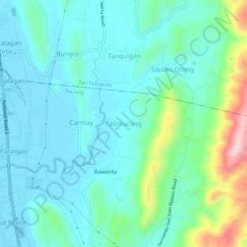
Name: Palintucang topographic map, elevation, terrain.

Location: Palintucang, Bauang, La Union, Philippines (16.54657 120.32228 16.58657 120.36228)

Average elevation: 66 m

Minimum elevation: 4 m

Maximum elevation: 308 m

Gear up for your next adventure:

🎒Backpack Rain Cover - External shield to keep your entire pack dry
🥾Mountain Hiking Boots - High-traction boots for rocky terrain
🔦LED Flashlight - Powerful and long-lasting flashlight for camping and emergencies
Backpacking Tent - Lightweight tent for long-distance hiking trips
🏕️Camping Hammock - Integrated protection for sleeping between trees

As an Amazon Associate, this site earns from qualifying purchases at no extra cost to you.