Geolocate

Hofgeismar topographic map

Click on the map to display elevation.

About this map

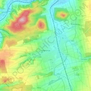
Name: Hofgeismar topographic map, elevation, terrain.

Location: Hofgeismar, Landkreis Kassel, Hesse, 34369, Germany (51.46285 9.31778 51.53651 9.43529)

Average elevation: 212 m

Minimum elevation: 128 m

Maximum elevation: 382 m

Other topographic maps

Click on a map to view its topography, its elevation and its terrain.

Hirschköpfchen

Germany > Hesse > Landkreis Kassel

Average elevation: 295 m

Trendelburg

Germany > Hesse > Landkreis Kassel

Average elevation: 199 m

Gear up for your next adventure:

💡LED Camping Lantern - Illuminate your campsite with long-lasting lanterns
🧤Insulated Winter Gloves - Heavy-duty protection for sub-zero Canadian adventures
🧰Multitool Knife - Compact and versatile tool for outdoor use
🧴Bear Spray Holster - Quick-access carry for essential Canadian wilderness safety
🥾Mountain Hiking Boots - High-traction boots for rocky terrain

As an Amazon Associate, this site earns from qualifying purchases at no extra cost to you.