Geolocate

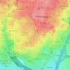
Moncloa-Aravaca topographic map

Click on the map to display elevation.

About this map

Name: Moncloa-Aravaca topographic map, elevation, terrain.

Location: Moncloa-Aravaca, Madrid, Community of Madrid, Spain (40.39910 -3.83835 40.48029 -3.70827)

Average elevation: 661 m

Minimum elevation: 577 m

Maximum elevation: 742 m

Other topographic maps

Click on a map to view its topography, its elevation and its terrain.
Madrid

Spain > Community of Madrid > Madrid

Average elevation: 650 m

Gear up for your next adventure:

🎒Backpack Rain Cover - External shield to keep your entire pack dry
🧢Hiking Hat - Sun-protective and breathable hats for long treks
🧴First Aid Kit - Essential first aid supplies for outdoor emergencies
🥾Lightweight Hiking Boots - Boots for comfort and mobility on long hikes
🧰Emergency Multi-Tool - Compact multi-tool for outdoor survival

As an Amazon Associate, this site earns from qualifying purchases at no extra cost to you.