Geolocate

Benus River topographic map

Click on the map to display elevation.

About this map

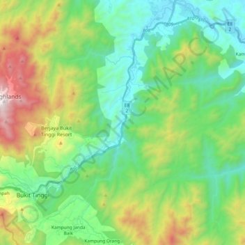
Name: Benus River topographic map, elevation, terrain.

Location: Benus River, Kampung Janda Baik, Bentong, Pahang, Malaysia (3.31108 101.85819 3.49638 101.93152)

Average elevation: 553 m

Minimum elevation: 73 m

Maximum elevation: 1,693 m

Gear up for your next adventure:

🩹Moleskin Blister Pads - Direct protection for painful foot pressure points
🥾Hiking Boots - Sturdy boots providing ankle support and traction on rugged trails
🧴First Aid Kit - Essential first aid supplies for outdoor emergencies
🔦LED Headtorch - Bright and durable light for night activities
🧴Insect Repellent - Protect yourself from bugs during outdoor adventures

As an Amazon Associate, this site earns from qualifying purchases at no extra cost to you.