
Make a donation
Gear up for your next adventure:
As an Amazon Associate, this site earns from qualifying purchases at no extra cost to you.
Aïn Oussara topographic map
Click on the map to display elevation.
Make a donation
Gear up for your next adventure:
As an Amazon Associate, this site earns from qualifying purchases at no extra cost to you.
Aïn Oussara
La ville de Aïn Oussara se trouve dans la limite nord de la zone des hauts-plateaux, à une altitude moyenne de 700 mètres. La topgraphie de la ville est globalement plate.
Make a donation
Gear up for your next adventure:
As an Amazon Associate, this site earns from qualifying purchases at no extra cost to you.
About this map
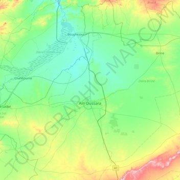
Name: Aïn Oussara topographic map, elevation, terrain.
Location: Aïn Oussara, Daïra Aïn Oussara, Djelfa, Algérie (35.16486 2.71942 35.82808 3.00847)
Average elevation: 736 m
Minimum elevation: 617 m
Maximum elevation: 1,177 m
Make a donation
Gear up for your next adventure:
As an Amazon Associate, this site earns from qualifying purchases at no extra cost to you.
Other topographic maps
Click on a map to view its topography, its elevation and its terrain.