
City of Corning topographic map
Interactive map
Click on the map to display elevation.
About this map
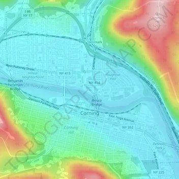
Name: City of Corning topographic map, elevation, terrain.
Location: City of Corning, Steuben County, New York, United States (42.13175 -77.07580 42.16434 -77.03073)
Average elevation: 336 m
Minimum elevation: 273 m
Maximum elevation: 530 m
Other topographic maps
Click on a map to view its topography, its elevation and its terrain.
Town of Fremont
United States > New York > Steuben County
Town of Fremont, Steuben County, New York, United States
Average elevation: 534 m
Corning
United States > New York > Steuben County > Corning
Corning, City of Corning, Steuben County, New York, 14831, United States
Average elevation: 391 m
Dyke
United States > New York > Steuben County > Dyke
Dyke, Town of Hornby, Steuben County, New York, United States
Average elevation: 517 m