Geolocate

Cloudland topographic map

Click on the map to display elevation.

About this map

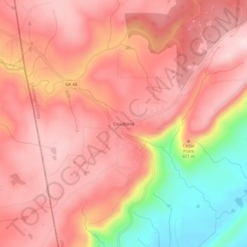
Name: Cloudland topographic map, elevation, terrain.

Location: Cloudland, Chattooga County, Georgia, 30731, United States (34.49592 -85.51441 34.53592 -85.47441)

Average elevation: 436 m

Minimum elevation: 248 m

Maximum elevation: 519 m

Other topographic maps

Click on a map to view its topography, its elevation and its terrain.

Trion

United States > Georgia > Chattooga County

Average elevation: 219 m

Lyerly

United States > Georgia > Chattooga County

Average elevation: 198 m

Gear up for your next adventure:

🧥Fleece Jacket - Warm and lightweight jacket for layering
🛌Down Sleeping Bag - Superior warmth-to-weight ratio for cold nights
🥾Trail Running Boots - Durable shoes designed for trail running
🔭Compact Monocular - One-handed bird watching and trail spotting
🧦Outdoor Socks - Durable socks designed for hiking and outdoor sports

As an Amazon Associate, this site earns from qualifying purchases at no extra cost to you.