Geolocate

Bako topographic map

Click on the map to display elevation.

About this map

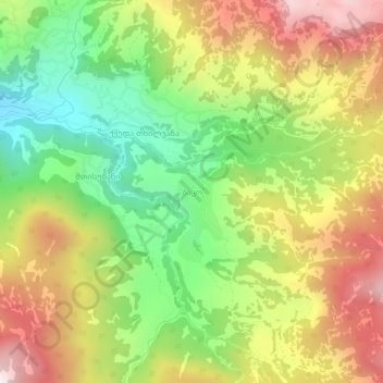
Name: Bako topographic map, elevation, terrain.

Location: Bako, Khulo Municipality, Autonomous Republic of Adjara, Georgia (41.52065 42.50930 41.56065 42.54930)

Average elevation: 1,672 m

Minimum elevation: 1,260 m

Maximum elevation: 2,145 m

Other topographic maps

Click on a map to view its topography, its elevation and its terrain.

Gear up for your next adventure:

🦯Trekking Poles - Reduced impact on joints for steep topographic climbs
🚲Bike Repair Kit - Essential tools for on-trail mechanical issues
🧥Fleece Jacket - Warm and lightweight jacket for layering
🕶️Polarized Sunglasses - Protect your eyes with durable polarized lenses
💡Portable Camping Lamp - Rechargeable lamp for campsite lighting

As an Amazon Associate, this site earns from qualifying purchases at no extra cost to you.