Geolocate

Waunakee topographic map

Click on the map to display elevation.

About this map

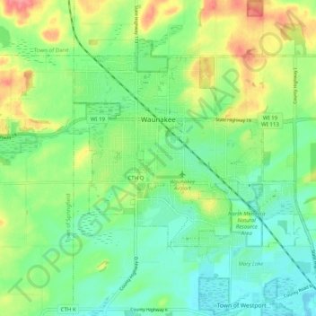
Name: Waunakee topographic map, elevation, terrain.

Location: Waunakee, Dane County, Wisconsin, 53597, United States (43.15936 -89.49148 43.20671 -89.38189)

Average elevation: 287 m

Minimum elevation: 257 m

Maximum elevation: 343 m

Other topographic maps

Click on a map to view its topography, its elevation and its terrain.

Waunakee Marsh

United States > Wisconsin > Dane County > Waunakee

Average elevation: 292 m

Buss's Corners

United States > Wisconsin > Dane County

Average elevation: 289 m

Table Bluff

United States > Wisconsin > Dane County

Average elevation: 306 m

Stoughton

United States > Wisconsin > Dane County > Stoughton

Average elevation: 270 m

Bowens Addition

United States > Wisconsin > Dane County > Madison

Average elevation: 266 m

Marxville

United States > Wisconsin > Dane County > Town of Berry

Average elevation: 300 m

East Bristol

United States > Wisconsin > Dane County

Average elevation: 285 m

Gear up for your next adventure:

🔭Compact Binoculars - Lightweight optics for scouting trails and wildlife
🪑Ultralight Camping Stool - Compact seating for rest stops during long hikes
🧥Softshell Jacket - Windproof and breathable jacket for hiking
🥾Trekking Poles - Adjustable trekking poles to reduce knee stress and improve stability
🥾Mountain Hiking Boots - High-traction boots for rocky terrain

As an Amazon Associate, this site earns from qualifying purchases at no extra cost to you.