
Rathen topographic map
Click on the map to display elevation.
About this map
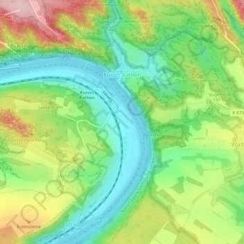
Name: Rathen topographic map, elevation, terrain.
Average elevation: 194 m
Minimum elevation: 110 m
Maximum elevation: 324 m
Other topographic maps
Click on a map to view its topography, its elevation and its terrain.
Topograph
Germany > Saxony > Sächsische Schweiz-Osterzgebirge > Rosenthal-Bielatal
Average elevation: 385 m
Kleiner Sandberg
Germany > Saxony > Sächsische Schweiz-Osterzgebirge > Lohmen
Average elevation: 266 m
Siamesische Zwillinge, Dick
Germany > Saxony > Sächsische Schweiz-Osterzgebirge > Bad Schandau
Average elevation: 366 m