
Aschach topographic map
Interactive map
Click on the map to display elevation.
About this map
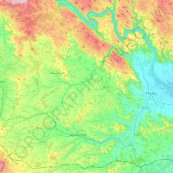
Name: Aschach topographic map, elevation, terrain.
Location: Aschach, Bezirk Grieskirchen, Austria (48.25030 13.64195 48.38987 14.10016)
Average elevation: 419 m
Minimum elevation: 257 m
Maximum elevation: 773 m
Other topographic maps
Click on a map to view its topography, its elevation and its terrain.
Wendling
Wendling, Bezirk Grieskirchen, 4741, Austria
Average elevation: 414 m